
Wareham Previous Residents by Era
A house history works best when its records are arranged by time. The Plymouth County deed trail identifies transfers and the legal description that follows a parcel through changes. Wareham assessment material bridges that trail to the present address. Directories, census schedules, and the local obituary index add the people who may have occupied the house. They should not be treated as one interchangeable list. A deed establishes a transfer, while a directory or census can place a household at an address near a particular date.
| Record source | Period available | Wareham access route | Address-history use |
|---|---|---|---|
| Plymouth deed books and indexes | 1685/1686 to current, with back-indexing caveats | TitleView, Registry stations, Plymouth and Brockton | Transfers, legal descriptions, plans, mortgages, and liens |
| Land Court records | 1899 to current | TitleView and Registry | Certificates and registered-land instruments |
| Vision assessment card | Current FY2026 card; older card depth not stated | Wareham assessor database | Owner, situs and mailing addresses, sale bridge, and parcel identifiers |
| Wareham directories | 1903–1904, 1907, 1910–1911, 1916, 1919, and 1926 | Massachusetts State Library | Householders, addresses, and occupation clues |
| Courier obituary index | 1905–1918 and 1931–1998 | Wareham Free Library Stone Research Room | Death notices, relatives, and address clues |
| Federal census | Public through 1950 | NARA and library genealogy services | Household composition and address geography |
For a recent transfer, start with the assessor card and deed. For an older household question, begin with the nearest verified directory year, then pair it with a census. The address is a useful starting point, but the parcel's legal description becomes the steadier identifier once street labels become uncertain.
Wareham Previous Residents in TitleView
The Plymouth County TitleView index is the principal route for a Wareham deed chain. It offers recorded-land name, book, date-range, document, and property searches, along with separate 1685–1969 grantor and grantee indexes. Plans have their own name, book, date, plan-number, and property routes. Registered land follows a different path through Land Court searches, certificates, and plans. Use the Towns selector to narrow a county-wide search to Wareham when the screen provides it.
The TitleView search screen below shows the separate recorded-land, registered-land, plan, and Plymouth Colony modes. Search and image viewing are free. Home printing requires a TitleView subscription, listed by the Registry as $30 per month, $1 per page, and a $60 non-refundable deposit credited to the account. Registry staff also handle certified-copy orders, with TitleView stating that mailed orders are processed within ten business days.
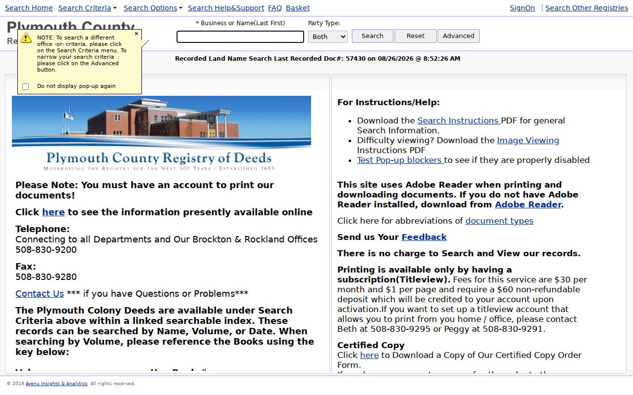
A name hit is only the first bridge. Compare the book and page, plan reference, consideration, seller, buyer, and legal description before deciding that a result belongs to the same Wareham property. Printed grantor and grantee volumes, public stations, and Registry staff remain the fallback when an older index path or plan search does not resolve the parcel.
Start a Wareham Previous Residents Search
Open the Wareham Vision assessment database with the present situs address. Situs means the physical location of the parcel. Record the owner, PID or map-lot number, last sale date and price, book and page, year built, and related parcels when displayed. Keep the owner mailing address separate from the situs address. A tax bill may go to a trust, an attorney, a post-office box, or an owner elsewhere, so it does not establish who occupied the house.
Wareham's current assessment maps, numbered 1 through 134 with submaps, can help when a street address has changed in everyday use. Their official disclaimer matters: assessment maps are not a legal description or a conveyance instrument. Use the map-lot geometry as a bridge to the deed, not as a substitute for the recorded document. A current assessment value is likewise not proof of a sale price or a person living on the parcel.
Keep the identifiers together. A street address, PID, map-lot, book and page, plan, and legal description often point to the same Wareham parcel from different record systems.
Trace Wareham Previous Residents by Deed
A chain of title is the sequence of ownership transfers for one parcel. It is built backward from the most recent purchase deed. In the deed, the person transferring the property is the grantor. The person receiving it is the grantee. The seller named in the current deed can be searched as an earlier grantee, then the same sequence can be repeated. This is why a legal description, plan, or map-lot must travel with each name search, especially when one person owned several Wareham parcels.
- Find the present parcel in Vision and note its book/page or other sale reference, PID or map-lot, and situs address.
- Open the purchase deed in TitleView by book and page, or search the owner or grantee with Wareham selected when available.
- Read the seller, buyer, recording date, consideration, legal description, plan reference, and any stated exceptions.
- Search that seller as a grantee in an earlier period, then compare the earlier deed's legal description against the same parcel.
- Repeat the transfer sequence, checking name-change, trust, probate, mortgage-discharge, and plan records where the deed points to them.
- For registered land, switch to the Land Court certificate route. Do not substitute a recorded-land book/page for a certificate number.
- Grantor / grantee
- The grantor transfers an interest; the grantee receives it. Their roles can reverse in different transactions.
- Chain of title
- A dated sequence of transfers connected by the same parcel's legal description, plan, or other stable identifiers.
- Legal description
- The recorded lot, bounds, plan, or certificate language that identifies land more reliably than a street number alone.
TitleView reaches unusually far back, but the Registry says back-indexing continues and some highway, taking, or plan material has separate or image-only coverage. If the online result trail breaks, use the Registry's public stations or ask about unindexed volumes and Brockton plan books.
Wareham Previous Residents and Maps
Maps and permits can date the physical house without identifying every past resident. Wareham's online permitting system began in 2019; Inspectional Services may have older paper material, while public fields for a live permit result should be confirmed before relying on them. A permit can supply an address, work type, date, applicant, status, and number when those fields are public. An applicant may be an owner, contractor, or agent, so it is evidence of work at the parcel rather than proof of who lived there.
The Library of Congress holds an 1832 Wareham town map and an 1885 panoramic map of Onset Bay Grove. Neither is a parcel survey, yet each can help date a village label, road pattern, resort lot, or shoreline setting. No Wareham-specific Sanborn map was verified in the research, so a Sanborn year should not be assumed. Historical map clues still need to be connected back to a recorded legal description or assessor map.
Wareham Past Residents in Directories
Deeds describe ownership, not every household. The verified State Library holdings include Wareham volumes for 1903–1904, 1907, 1910–1911, 1916, 1919, and 1926. An entry may supply a surname, given name or initial, spouse or widow notation, occupation, address, boarder wording, and an abbreviation key. Exact layout varies by volume, so read its front matter before assigning meaning to an abbreviation. The underlying collections are described on the Wareham city directory page.
- Choose the verified directory year nearest to the household period and record each name, address spelling, relationship note, and occupation clue.
- Check the same address or street section if the volume includes one, and note whether it appears under Onset, East Wareham, West Wareham, or another village label.
- Pair the directory with the closest public federal census, allowing for the directory's compilation date and the census enumeration date.
- Use a later directory, obituary, probate file, or deed of distribution to document a move, death, estate, or transfer.
Federal census schedules are public through 1950. The 1890 federal schedules were largely lost nationwide, so a missing 1890 household cannot be repaired by an ordinary complete census search. A nearby directory, town record, deed, or newspaper notice can sometimes bridge that gap.
Wareham Previous Residents at Stone Room
The Celia Epstein Stone Research Room at Wareham Free Library is the local fallback for obituary, cemetery, map, clipping, yearbook, and Courier research. The current notice says the room is open by appointment. Call the library at 508-295-2343 extension 0 for details. Staff can search the hard-copy obituary index at extension 1012 if the hosted index is unavailable, and article or obituary copies are listed at $3 per article. The Historical Society preserves five properties but explicitly says it has no library or staff for genealogy or property-search work.
The Courier index covers 1905–1918 and 1931–1998, sorted by surname. Its gap is meaningful. A 1938 hurricane and flood destroyed intervening Courier issues at the newspaper office, and some early pages were unnumbered and marked N/L in the index. Treat a failed obituary search during those years as an archive gap, not proof that a resident was absent. Probate cards, the digitized PAL Map, and the 1883–1908 Douglass/MacElmo Summer Journal are additional local materials available for on-site review at Town Hall or the library.
Village Labels for Wareham Addresses
Wareham records can use Wareham, Wareham Center, Onset, East Wareham, West Wareham, Agawam, Tihonet, or Great Neck. These are local, historical, or postal descriptions within one town government, not separate modern municipalities. West Wareham was part of Rochester before Wareham's 1739 incorporation, and Tihonet came from Carver and Plymouth in the 1700s. Search those variants beside the owner name, plan, and legal description when an older record does not match a modern address.
No official research source verified a town-wide street renumbering or a renamed-street year. Do not force an old address into a new number. Compare nearby owner names, parcel geometry, village labels, assessment maps, and recorded plan references first.
Respecting Past Wareham Residents
House history, family history, estate research, and local curiosity are appropriate reasons to examine these sources. Public access does not make it acceptable to track, threaten, repeatedly contact, or publish sensitive details about living people. Massachusetts treats stalking and criminal harassment seriously under M.G.L. c.265 §§ 43 and 43A.
Use the record for the house, not harm. Confirm a deed, directory, obituary, or map with its custodian and respect protected information, especially when the trail reaches a living person.